Advanced Drone Survey Solutions in Jaipur, Rajasthan: The Future of Aerial Intelligence
In the rapidly evolving landscapes of Engineering, Construction, Agriculture, and Environmental Management, traditional surveying methods are being replaced by high-precision aerial intelligence. VS Safety and Drones, based in Jaipur, is at the forefront of this revolution, providing state-of-the-art UAV drone surveys that deliver unmatched accuracy, safety, and speed.
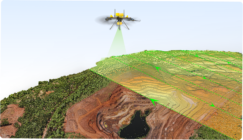
From the rugged terrains of Rajasthan to complex urban planning projects, our drone solutions provide the high-resolution imagery and 3D data required for modern industrial success.
Our Core Expertise: Industry-Specific Drone Applications
1. Engineering & Construction
Maximize efficiency on the job site with precision data:
- Topographic Mapping: Accurate site planning and design phases.
- Progress Monitoring: High-definition time-lapse views for stakeholder reporting.
- Volumetric Analysis: Rapid stockpile measurements for materials management.
- Geotechnical Analysis: Slope stability and terrain deformation monitoring.
2. Geology & Hydrogeology
Unlock sub-surface insights through surface intelligence:
- Feature Mapping: Identifying fault lines, fractures, and lithology.
- Watershed Delineation: Analyzing drainage patterns and flood risks.
- Thermal Seepage Detection: Using thermal sensors to locate groundwater springs.
3. Agriculture & Environmental Monitoring
Driving sustainability through “Precision Ag” technology:
- Multispectral Crop Health: Early detection of pests, disease, and nutrient deficiencies.
- Soil & Moisture Mapping: Optimizing irrigation and land use.
- Forestry & Wildlife: Tracking vegetation changes and monitoring local ecosystems.
4. Urban Planning & Land Management
Building smarter cities with 3D data:
- 3D City Modeling: Detailed digital twins for zoning and development.
- Encroachment Detection: Verifying boundaries and identifying unauthorized land use.
- Disaster Management: Rapid mapping for flood, landslide, and emergency response.
The VS Safety & Drones Workflow: How We Ensure Precision
We follow a rigorous 7-step technical process to ensure every data point is actionable and accurate:
- Mission Planning: Defining AOIs (Areas of Interest) and selecting optimal sensors (RGB, LiDAR, or Thermal).
- Ground Control (GCPs): Establishing physical coordinate markers for centimeter-level georeferencing.
- Autonomous Execution: Deploying advanced UAVs using pre-programmed flight paths and real-time telemetry.
- Data Acquisition: Capturing high-overlap imagery to eliminate motion blur and data gaps.
- Photogrammetry Processing: Generating Orthomosaics, Digital Elevation Models (DEM), and Contour Maps.
- Accuracy Validation: Utilizing RTK (Real-Time Kinematic) and PPK corrections to verify data integrity.
- GIS Integration: Delivering outputs in CAD-ready formats for seamless workflow integration.
Overcoming Industrial Challenges
While drone technology is powerful, it requires expertise to navigate limitations. At VS Safety and Drones, we manage the complexities of:
- Regulatory Compliance: Handling all DGCA permits and “No-Fly Zone” authorizations.
- Data Complexity: Using high-end processing hardware to turn raw images into 3D intelligence.
- Operational Safety: Strict protocols to manage weather dependencies and battery endurance for large-scale surveys.
Why Choose VS Safety and Drones?
Based in the heart of Jaipur, Rajasthan, we combine local geographical knowledge with world-class UAV technology. Whether you are mapping a new highway, inspecting a solar farm, or monitoring crop yields, we provide the “eye in the sky” that keeps your project grounded in facts.
Experience the difference where precision meets safety.
[Contact our Jaipur Team Today for a Consultation]